
Postcrossing
is all about the luck of the draw. The people
you get cards from, the quality of the cards, the way in which they fit your
interests, and, in no small measure, where they come from.

As soon as I
saw the postcrossing ID number on this one I knew I had a winner! It was PM-355. Only the 355th postcard sent from
that country. But where was PM. I couldn’t guess. So I had to look at the stamp and the front
of the card.
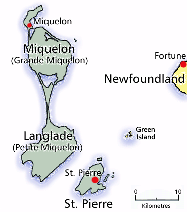
It was from
Saint Pierre et Miquelon. Located in the
heart of the Grand Banks in the North Atlantic, 25 km southwest of
Newfoundland, the archipelago of Saint Pierre and Miquelon is composed of eight
islands, totalling 242 km2, of which only two are inhabited - Saint
Pierre Island and Miquelon-Langlade, the largest island, which is in fact
composed of two islands, Miquelon being connected to Langlade by the Dune de
Langlade, a 10 km-long sandy isthmus. A storm had severed them in the 18th century,
separating the two islands for several decades, before currents reconstructed
the isthmus. The waters between Langlade and Saint-Pierre
were called "the Mouth of Hell" (French: Gueule d'Enfer) until about
1900, as more than 600 shipwrecks have been recorded in that point since 1800. Langlade Island is almost deserted (only one inhabitant
in the 1999 census). The islands are bare and rocky, with steep coasts, and
only a thin layer of peat to soften the hard landscape.

Saint Pierre
and Miquelon is a self-governing territorial overseas collectivity of France,
situated in the northwestern Atlantic Ocean near Canada. It is the only remnant of the former colonial
empire of New France that remains under French control. The islands of
Saint-Pierre and Miquelon were discovered by Europeans on 21 October 1520, by
the Portuguese João Álvares Fagundes, who bestowed on them their original name
of "Islands of the 11,000 Virgins", as the day marked the feast day
of St. Ursula and her virgin companions. They were made a French possession in
1536 by Jacques Cartier on behalf of the King of France.
Though
already frequented by Micmac Indians and Basque and Breton fishermen, the
islands were not permanently settled until the end of the 17th century: four
permanent inhabitants were counted in 1670, and 22 in 1691. The islands were ceded to Great Britain in
1713 and back to France in 1814. The
estimated population now is 5,888, most of whom live in the city of St Pierre. The Village of Miquelon has a population of less than a thousand.

postcard no 260
The islands
are situated at the entrance of Fortune Bay, which extends into the southern
coast of Newfoundland, near the Grand Banks.
They are 3,819 kilometres (2,373 mi) from Brest, the nearest point in
Metropolitan France but just 20 kilometres (12 miles) off the Burin Peninsula
of Newfoundland.

Smuggling
had always been an important economic activity in the islands, but it became
especially prominent in the 1920s with the institution of prohibition in the
United States.[18] In 1931, the archipelago was reported to have imported
1,815,271 US gallons (6,871,550 litres) of whisky from Canada in 12 months,
most of it to be smuggled into the United States. The end of prohibition in 1933 plunged the
islands into economic depression.
Every year
in the summer there is a Basque Festival, with demonstrations of
harrijasotzaile (stone heaving), aizkolari (lumberjack skills), and pelota. The
local cuisine is mostly based on seafood such as lobster, snow crab, cod,
mussels and many cod-based dishes. Ice hockey is very popular in Saint-Pierre
and Miquelon.
No comments:
Post a Comment
Welcome. I love it when visitors comment - even if it's only to say "Hi, I've been here!"